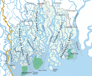
 Sundarban is nearly 2400 sq. miles or 6000 sq. km. It has some part in India and rest of the part in Bangladesh.
 The forest limit can be categorise as: North-Bagerhat, Khulna and Sathkira districts : South-Bay of Bengal; East-Baleswar (or Haringhata) river, Perojpur, Barisal district, and West-Raimangal and Hariabhanga rivers which partially form Bangladesh boundary with West Bengal in India.

Sundarbans National Park is the largest estuarine mangrove forest in the world. Twenty-six of the fifty broad mangrove types found in the world grow well in the Sundarbans. The commonly identifiable vegetation that grow in the dense mangrove forests at the Sundarbans are salt water mixed forest, mangrove scrub, brackish water mixed forest, littoral forest, wet forest and wet alluvial grass forests.

No comments:
Post a Comment